
IN BRIEF
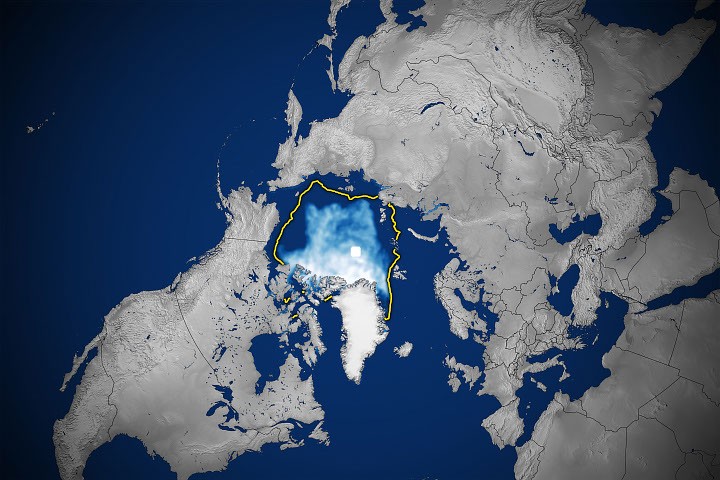
The estimated Arctic minimum on 12 September 2026 was 4.60 million square kilometres of sea-ice extent.
The value tied 2008, 2010 and 2025 for tenth lowest; all 20 smallest summer lows in the satellite record occurred during 2007-2026.
Extent is not total ice volume or thickness, and the minimum was initially designated preliminary.
WHY IT MATTERS
This was not a new absolute record. The striking fact is persistence: twenty consecutive years now account for all twenty lowest summer sea-ice extents of the satellite era. A relatively cool Arctic summer can limit one year's melting without restoring the conditions of earlier decades.
Sea-ice cover affects ecosystems, marine access and heat exchange between ocean and atmosphere. A ranking alone does not measure each downstream effect, but it documents a durable shift in the physical system.
WHAT IS NOW POSSIBLE
Before: larger summer ice coverage in earlier decades; now: the full twenty smallest satellite-era minima occurred from 2007 to 2026.
WHAT MADE IT POSSIBLE
NASA and NSIDC use satellite passive-microwave sensors to distinguish sea ice from open water through cloud cover, allowing regular observations across the Arctic.
The nearly continuous record reaches back to late 1978. Different sensor products and analysis rules can generate somewhat different values, so rankings must be tied to a stated data series.
THE STORY
The Arctic did not set a new all-time low for summer sea ice in 2026. Still, the season produced a significant result: on 12 September the floating ice cover reached an estimated 4.60 million square kilometres, tying for the tenth-lowest minimum since satellite monitoring began in the late 1970s. NASA and the National Snow and Ice Data Center (NSIDC) report that every one of the twenty smallest annual summer minima occurred in the twenty consecutive years from 2007 through 2026.
The annual minimum is the point after summer melting when the measured extent is smallest. Extent is defined by the area of ocean grid cells containing at least 15 percent sea ice. It does not directly measure ice thickness, mass or volume. NSIDC uses a short temporal average to dampen rapid weather-driven fluctuations when identifying the annual low.
The 2026 value tied those for 2008, 2010 and 2025. It remains above the satellite-era record of roughly 3.39 million square kilometres recorded in 2012. Both comparisons matter: 2026 was not the worst year, but a less exceptional summer does not imply a return to twentieth-century Arctic conditions. NSIDC's October analysis describes a relatively cool, stormy summer over the central Arctic Ocean and scattered ice extending toward the pole in the Atlantic sector.
Passive microwave sensors observe the ice repeatedly even through clouds. Their long record shows a smaller Arctic ice cover at both seasonal extremes and a decline in older multi-year ice that survives summer melting. These findings concern the changing state of the planet, rather than a new technology capability. The October 7 NASA article provided fresh visualization of a measurement that had already been reported in September.
The reported minimum was initially preliminary because wind-driven compaction and ice movement can shift extent over a few days. Different observing products also use different sensors, averaging windows and processing rules; their absolute values should not be compared indiscriminately. The demonstrated result is a persistently low summer extent in a consistent satellite series. Specific future effects on navigation, wildlife and climate require separate evidence.
WHAT WE KNOW
NASA and NSIDC report a 4.60-million-square-kilometre Arctic minimum on 12 September 2026, tied for tenth lowest. [1][2][3]
The 20 smallest annual minima in the satellite record all occurred from 2007 to 2026.
The long-term record also shows less multiyear ice and lower winter peaks than in earlier decades.
WHAT WE DON'T KNOW
Sea-ice extent by itself does not specify thickness or total volume.
A single annual minimum cannot quantify precise local impacts on shipping or ecosystems.
Rankings derived from different measurement products require method-by-method comparison.
WHAT HAPPENS NEXT
Follow the autumn freeze-up and the winter 2027 maximum using the same underlying series.
Assess extent alongside ice concentration, age and thickness where measurements permit.
Revise estimates if the observational agency issues an updated seasonal value.
SOURCE TRACE
The 12 September 2026 Arctic minimum is estimated at 4.60 million km².
The 2026 minimum tied 2008, 2010 and 2025 for tenth lowest.
The twenty smallest annual minima occurred in 2007-2026.
Sea-ice extent does not directly measure thickness or volume.
SOURCES
- Arctic Sea Ice Shrinks to Its 2026 MinimumOpen source
- Arctic sea ice has reached minimum extent for 2026; Antarctic sea ice maximum most likely reached as wellOpen source
- Stranger Things in the 2026 ArcticOpen source
CURRENT EVIDENCE
VALIDATED EVIDENCE
OBSERVED ANNUAL PHYSICAL STATE / REPORTED SEPTEMBER 2026
WHAT WOULD CHANGE THIS?
- NSIDC revisions could change the exact reported value or a tie.
- Thickness data could clarify changes in ice volume beyond extent alone.
- Future summer minima will change the historical ranking as new seasons are observed.